 Minnesota Sinkholes & Subsidences
Sinkholes in Minnesota Karst & at Seawalls along Lake Superior & Other Seawalls
- POST a QUESTION or COMMENT about sinkholes and their effects on buildings
Sinkholes in Minnesota:
This article describes karst-formation based sinkholes in southeastern and other areas of Minnesota and it also discusses the causes and effects of subsidences and sinkholes forming along seawalls in Minnesota at docks along Lake Superior as well as in other parts of the world.
This article series explains what sinkholes are and why they occur, describes their effects on buildings, and gives building and site inspection advice useful in identifying areas where there is an increased risk of sink holes at properties.
We include the causes of sinkholes, how they can be spotted, sometimes before a sudden collapse, and what to do if you know or suspect that a sinkhole is developing on or close to your property.
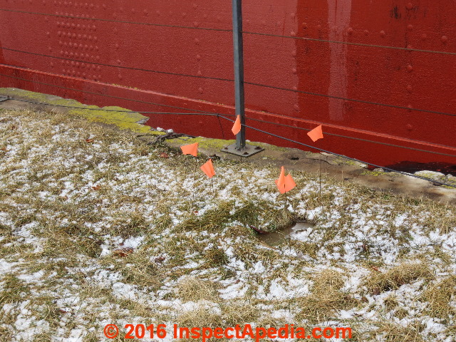
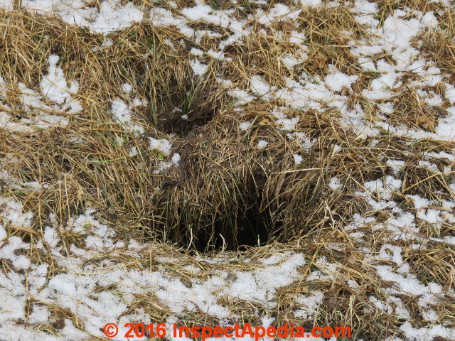
Page top photo: a sinkhole opening in Duluth, Minnesota, photographed by the author (D Friedman).
InspectAPedia tolerates no conflicts of interest. We have no relationship with advertisers, products, or services discussed at this website.
- Daniel Friedman, Publisher/Editor/Author - See WHO ARE WE?
Sinkholes & Seawall Subsidences in Minnesota
Some Minnesota sinkholes are large enough to serve as tourist attractions, such as by the Minnesota DNR-constructed observation deck at a sinkhole on the Root River Trail in Fountain MN.
And Minnesota's Fillmore county, billing itself as the "sinkhole capital of the U.S." boasts more than 10,000 sinkholes.
Karst formations in the southeastern part of Minnesota explain a high number of sinkholes and also play a role in the transport of groundwater contaminants.
Other, less famous subsidences and sinkholes can occur along lake Superior, particularly at seawalls subject to the eroding effects of waves and water movement from ships in harbors.
Sinkholes & Waterfront Seawall Subsidence along Lake Superior in Duluth Minnesota
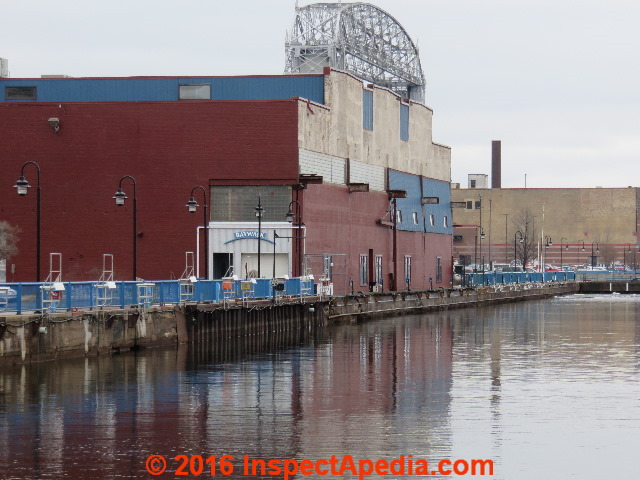
Below, a section of seawall along the harbor walk in Duluth Minnesota. Canal Park's Duluth Lift Bridge, aka the Duluth Aerial Lift Bridge is visible in the upper portion of this photo.
In 2016 small sinkholes were reported along the Duluth Minnesota waterfront.
These subsidences in Duluth were considered dangerous and a particular hazard to the public along the tourist area of the waterfront near the Duluth Entertainment Convention Center (DECC) where aging seawalls along docks permit wave, tidal, and other water actions that penetrate the original seawall facade to erode filled soil behind the seawall in areas where people may walk. (Nakamura et als. 2008).
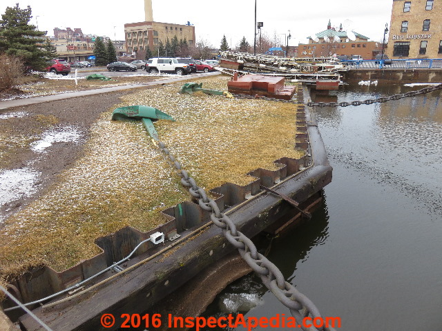
Above is a more recently-constructed steel and timber seawall where during an inspection tour in March 2016 the author (DF) did not observe sinkholes though such subsidences were visible at older seawalls quite nearby.
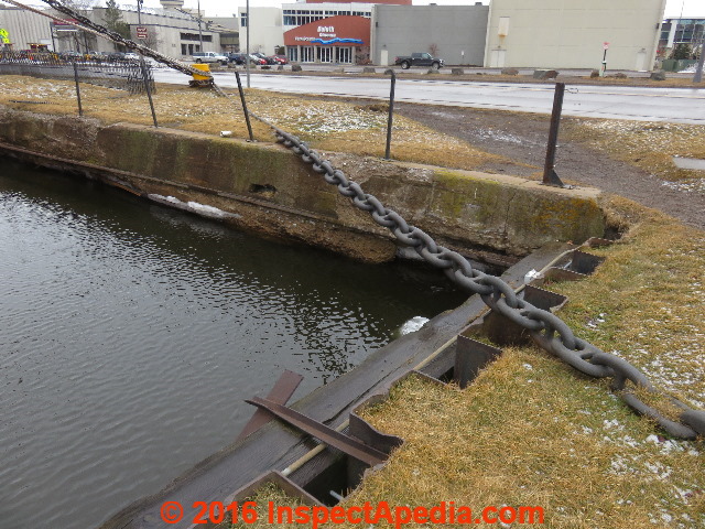
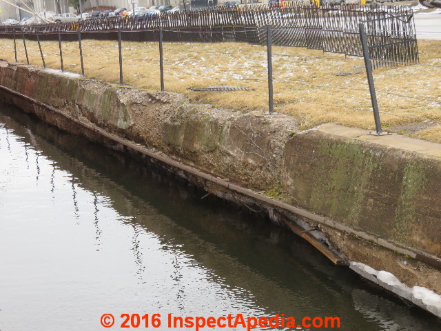
Even modern driven steel seawalls such as this one can eventually corrode, rust-through, and permit leaks and subsidences. Below we see an intersection of newer steel seawall (photo foreground) with older poured concrete and timber seawalls (background in the photo).
Sinkholes (or earth subsidences) at seawalls are a common phenomenon occurring anywhere that seawalls encounter forces of moving water such as tides, waves, or boat and ship traffic, or where older seawalls or seawall caps have deteriorated permitting water to move behind the seawall where it can attack backfill and infill.
And while karst formations, the most common ingredient in sinkhole formation, are sometimes present where seawalls are also constructed (Gombert et als. 2015), karst is probably not a factor in the Duluth seawall subsidences.
Above: a closer view of the older concrete (and timber) seawall in Duluth.
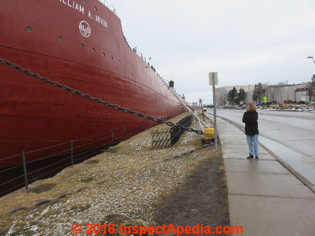
Duluth, Minnesota sinkholes drew particular attention near the steamer William A Irvin, a retired ore carrier (lake freighter) built in 1938 and now a museum and a national historic monument open to the public at the Lake Superior waterfront.
The Duluth News Tribune reported that 25,000 people visited the freighter in 2015, making pedestrian safety an important concern. (Slater, 2016)
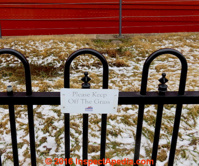
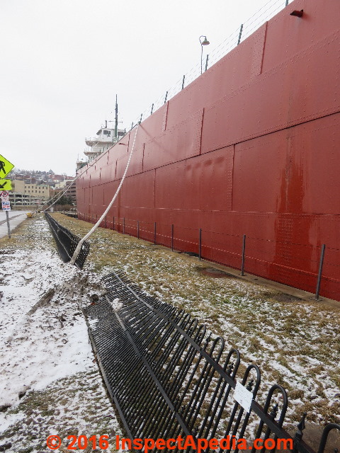
Authorities erected fencing and modest (keep off the grass) warning signs to keep people from walking in the area where subsidence and sinkholes were observed at the the Duluth waterfront.
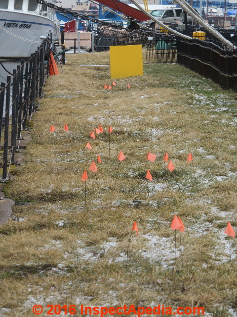
Engineers or other experts also placed small red flags to help monitor the development of sinkholes in Duluth as we illustrate here.
Significant costs will be involved in repairing or replacing seawalls damaged by these forces. Possibly of aid are special products such as steps that break wave actions against the seawall (Nolan 2000).
Below, the huge length of the retired lake freighter occupies a stunning length of dock footage in Duluth. Numerous low spots, wet areas and actual sinkholes were visible in the fenced-off area along the dock.
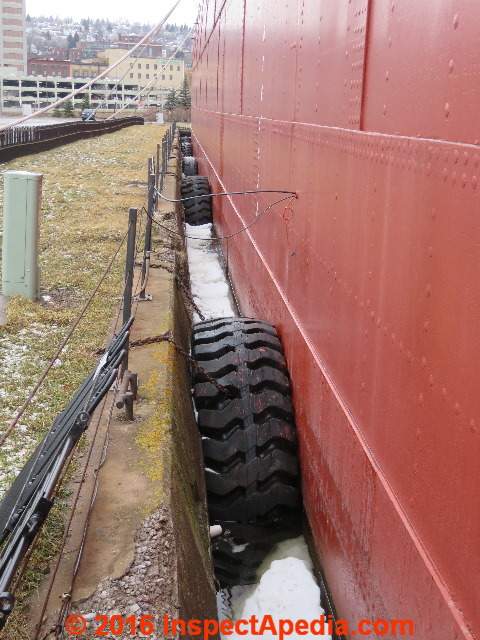
While lake Superior is not tidal its water levels do vary over time but probably more significant as a force in sea-wall wear and resultant soil loss from behind the seawall are the combined forces of wave action and ship traffic or even the agitation of water between a permanently docked steamer William A. Irvin and the seawall (below).
 "Sinkholes" that are not verified by a licensed professional geologist or geotechnical engineer to be a true sinkhole are also described in various publications as subsidence incidents.
Readers should see SINKHOLES - IMMEDIATE SAFETY ACTIONS, and also see FOUNDATION CRACKS & DAMAGE GUIDE and CESSPOOL SAFETY WARNINGS.
Additional septic system safety warnings are at SEPTIC & CESSPOOL SAFETY.
The bare minimum that a property owner needs to know about sinkholes or any other sudden subsidence of soils at a property is that these conditions might be very dangerous.
Someone falling into a sink hole or into a collapsing septic tank could be seriously injured or even die.
If a suspicious hole, subsidence, or depression appears at a property the owner should rope off and prevent access to the area to prevent anyone from falling into the opening, and then should seek prompt assistance from a qualified expert, geotechnical engineer, septic contractor, excavator, or the like.
Minnesota sinkhole research
- Alexander, Jr., E., and P. R. Book. "Altura Minnesota lagoon collapses." In Multidisciplinary conference on sinkholes. 1, pp. 311-318. 1984.
- Dalgleish, Janet, and E. C. Alexander Jr. "Sinkhole distribution in Winoma County, Minnesota." In Multidisciplinary conference on sinkholes. 1, pp. 79-85. 1984.
- Gombert, Philippe, Julie Orsat, David Mathon, Rafid Alboresha, Marwan Al Heib, and Olivier Deck. "Role of karst collapses on the disorders occurring on the seawalls of Loire in the Valley of Orleans (France)." Bulletin of Engineering Geology and the Environment 74, no. 1 (2015): 125-140.
- Hubbard Jr, David A. "Sinkhole distribution in the central and northern Valley and Ridge province, Virginia." In Multidisciplinary conference on sinkholes. 1, pp. 75-78. 1984.
- "Karst, Minnesota County/Regional Geology Data" [Website], Minnesota Geospatial Information Office, retrieved 2016/03/17, original source: http://www.mngeo.state.mn.us/chouse/geology/county_regional.html This data includes a database and interactive map of sinkholes and other karst features in Minnesota and links to the Thompson citation given below.
Excerpt:
Karst is an efficiently drained landscape that forms on soluble rock, typified by caves, sinkholes and other landforms. It is mainly, but not exclusively, formed on limestone. In Minnesota, karst is generally found in the southeastern area and in Pine County. - Nakamura, Tomoaki, Dong-Soo Hur, and Norimi Mizutani. "Mechanism of backfilling sand discharge from a gap under vertical revetment." Journal of waterway, port, coastal, and ocean engineering 134, no. 3 (2008): 178-186.
- Nolan, Don E. "WavBrakerSteps for waterfront bulkheads, seawalls and seacoast." U.S. Patent 6,050,745, issued April 18, 2000.
- Rosen, P. S., and D. B. Vine. "Evolution of seawall construction methods in Boston Harbor." [PDF], Proc. Instn Civ. Engrs Structs & Bldgs, 1995, 110, Aug., 239-249, Structural and Building Board Structural Panel Paper 10539.
This interesting paper includes description of early seawall construction in colonial America such as a colonial cobb wharf crib constructed of notched, trunnelled logs at the Douglass Wharf, New London Connecticut. - Slater, Brady, "Decaying dock wall rises as priority", Duluth News Tribune, 6 Marh 2016, p. 1. Website: duluthnewstribune.com
- Stuart, Duncan, and Sahil Patel. "Maintenance and rehabilitation of sea walls and revetments between the Glencairn and Simonstown stations." Civil Engineering (2011): 17.
- Taqieddin, S. A., N. S. Abderahman, and M. Atallah. "Sinkhole hazards along the eastern Dead Sea shoreline area, Jordan: a geological and geotechnical consideration." Environmental geology 39, no. 11 (2000): 1237-1253.
Abstract:
For the last four decades, the level of the Dead Sea has been subjected to continual variation which, among other important factors, has led to the occurrence of much subsidence and many sinkholes in the southern Dead Sea area.
Sinkhole activities occurred repetitively and were observed in open farms, across roads, near dwellings and near an existing factory, thus causing a serious threat to the locals and farmers of the area and their properties.
This paper presents the main results from detailed geological and geotechnical studies of this area. Aerial photo interpretation and borehole drilling aided these studies. Parallel geophysical investigations (vertical electrical sounding and seismic refraction) and hydrological and hydrogeological studies were made by others in the same area to also investigate this phenomenon.
It was found that sinkholes are aligned to and follow old water channels and are concentrated parallel to the recent shoreline of the Dead Sea.
The development of subsurface cavities is associated mainly with the variation in the level of the Dead Sea over the four past decades, the presence of regional salt intrusion under the surface of salt beds, the fluctuation of the water table and continuous dissolution and the active tectonism of the area.
Moreover, this work showed that the area is still under active sinkhole hazards and other parts of the area will be inevitably affected by sinkholes in the future. No practical engineering solution to this problem is feasible. - Thompson, Steve, "Karst in Minnesota", Minnesota Pollution Control Agency, (Web page), retrieved 2016/03/17, original source: https://www.pca.state.mn.us/water/karst-minnesota
- Wu, N., and Y. Chou. "Sinkholes Problem Happened In Access Road Behind Sea Wall", Publication of: Shaker Verlag GmbH (1998).
Abstract:
After several typhoons attacked the west coast of Taiwan in summer 1994, severe damages appearing as sinkholes beside the access road or in the middle of the access road were observed. The sinkholes reappeared some time after the holes were filled.
Through the field investigation that especially focused on the sinkholes that appeared in the middle of the access road, it is believed that piping phenomena is the major reason for the damage.
The reason for the sinkholes beside the access road is assumed to be the excessive pressure resulting from the so called venting effect which was first mentioned in similar case that happened in Tripoli Harbour NE Breakwater in Libya.
Minnesota Seawall & Bulkhead Resources
- PileBuck, "Chapter 3 - Seawalls", [web article, print magazine, CD Rom articles] Pile Buck Magazine, P.O. Box 64-3609 Vero Beach, FL 32964-3299 USA, Tel: 866-573-0708, Email: info@pilebuck.com - retrieved 2016/06/21, original source: http://www.pilebuck.com/publications/seawalls-bulkheads-quaywalls/chapter-2-protective-waterfront-structures/
- PileBuck, "Chapter 4 - Bulkheads", [web article] Pile Buck Magazine, P.O. Box 64-3609 Vero Beach, FL 32964-3299 USA, Tel: 866-573-0708, Email: info@pilebuck.com - retrieved 2016/06/21, original source: http://www.pilebuck.com/publications/seawalls-bulkheads-quaywalls/chapter-4-bulkheads/
...
Continue reading at SINKHOLES & SUBSIDENCES - topic home, or select a topic from the closely-related articles below, or see the complete ARTICLE INDEX.
Or see these
Sinkhole & Subsidence Articles
- CREOSOTE HAZARDS at seawalls made of creosote-treated piles
- SEPTIC & CESSPOOL SAFETY
- SINKHOLES & SUBSIDENCES - home
- SINKING BUILDINGS
Suggested citation for this web page
SINKHOLES in MINNESOTA at InspectApedia.com - online encyclopedia of building & environmental inspection, testing, diagnosis, repair, & problem prevention advice.
Or see this
INDEX to RELATED ARTICLES: ARTICLE INDEX to SINKHOLES
Or use the SEARCH BOX found below to Ask a Question or Search InspectApedia
Ask a Question or Search InspectApedia
Questions & answers or comments about sinkholes and their effects on buildings.
Try the search box just below, or if you prefer, post a question or comment in the Comments box below and we will respond promptly.
Search the InspectApedia website
Note: appearance of your Comment below may be delayed: if your comment contains an image, photograph, web link, or text that looks to the software as if it might be a web link, your posting will appear after it has been approved by a moderator. Apologies for the delay.
Only one image can be added per comment but you can post as many comments, and therefore images, as you like.
You will not receive a notification when a response to your question has been posted.
Please bookmark this page to make it easy for you to check back for our response.
IF above you see "Comment Form is loading comments..." then COMMENT BOX - countable.ca / bawkbox.com IS NOT WORKING.
In any case you are welcome to send an email directly to us at InspectApedia.com at editor@inspectApedia.com
We'll reply to you directly. Please help us help you by noting, in your email, the URL of the InspectApedia page where you wanted to comment.
Citations & References
In addition to any citations in the article above, a full list is available on request.
- Florea, Lee J. "Using State-wide GIS data to identify the coincidence betwen sinkholes and geologic structure." Journal of Cave and Karst Studies 67, no. 2 (2005): 120-124.
- Waltham, Tony, Frederic Gladstone Bell, and M. G. Culshaw, Sinkholes and subsidence, Springer/Praxis, 2005.
- [1] Thomas V. Cech, Principles of water resources: history, development, management, and policy, John Wiley and Sons 2009 ISBN0470136316, 9780470136317
- [4] Buried oil tank collapse, subsidence, in condominium association meeting minutes, private correspondence, DF with attorney. 02/21/2012.
- [6] "A Little House on the Catastrophically Damaged Prarie", Wes Enzinna, The New York Times Magazine, 20 May 2012, p. 34-39.
- "Quick Clay", Wikipedia search 5/13/2010 - http://en.wikipedia.org/wiki/Quick_clay
- "Frost Heaving Forces in Leda Clay", Penner, E., Division of Building Research, National Research Council of Canada, Canadian Geotechnical Journal, NRC Research Press, 1970-2, Vol 7, No 1, PP 8-16, National Research Council of Canada, Accession number 1970-023601, Quoting from original source
The frost heaving forces developed under a 1 ft. (30.5 cm) diameter steel plate were measured in the field throughout one winter. The steel plate was fixed at the ground surface with a rock-anchored reaction frame. heave gauges and thermocouples were installed at various depths to determine the position and temperature of the active heaving zone. The general trend was for the surface force to increase as the winter progressed. when the frost line approached the maximum depth the force was in excess of 30,000 lb (13,608 KG).
Estimates of the heaving pressure at the frost line ranged from 7 to 12 psi (0.49 to 0.84 KG/cm) square during this period. The variation of surface heaving force was closely associated with weather conditions. Warming trends resulting in a temperature increase of the frozen layer caused the forces to decline. - "Geoscape Ottowa-Gatineau Landslides", Canada Department of Natural Resources, original source http://geoscape.nrcan.gc.ca/ottawa/landslides_e.php - quoting from that source:
Leda clay slopes in the Ottawa valley are vulnerable to catastrophic landslides. More than 250 landslides, historical and ancient, large and small, have been identified within 60 km of Ottawa. Some of these landslides caused deaths, injuries, and property damage, and their impact extended far beyond the site of the original failure. In spectacular flowslides, the sediment underlying large areas of flat land adjacent to unstable slopes liquefies.
The debris may flow up to several kilometres, damming rivers and causing flooding, siltation, and water-quality problems or damaging infrastructure. Geologists and geotechnical engineers can identify potential landslide areas, and appropriate land-use zoning and protective engineering works can reduce the risk to property and people.Deposits of Leda clay, a potentially unstable material, underlie extensive areas of the Ottawa-Gatineau region. Leda clay is composed of clay- and silt-sized particles of bedrock that were finely ground by glaciers and washed into the Champlain Sea. As the particles settled through the salty water, they were attracted to one another and formed loose clusters that fell to the seafloor.
The resulting sediment had a loose but strong framework that was capable of retaining a large amount of water. Following the retreat of the sea, the salts that originally contributed to the bonding of the particles were slowly removed (leached) by fresh water filtering through the ground. If sufficiently disturbed, the leached Leda clay, a weak but water-rich sediment, may liquefy and become a 'quick clay'.
Trigger disturbances include river erosion, increases in pore-water pressure (especially during periods of high rainfall or rapid snowmelt), earthquakes, and human activities such as excavation and construction.After an initial failure removes the stiffer, weathered crust, the sensitive clay liquefies and collapses, flowing away from the scar. Failures continue in a domino-like fashion, rapidly eating back into the flat land lying behind the failed slope. The flowing mud may raft intact pieces of the stiffer surface material for great distances.
- Kochanov, W. E., 1999, Sinkholes in Pennsylvania: [PDF] Pennsylvania Geological Survey, 4th ser., Educational Series 11,
33 p., 3rd printing April 2005, Pennsylvania Department of Conservation and Natural Resources / Bureau of Topographic and Geologic Survey, DCNR Educational Series 11, Pennsylvania Geological Survey, Fourth Series, Harrisburg,
1999 - web search 06/05/2010, original source: http://www.dcnr.state.pa.us/topogeo/hazards/es11.pdf - Quoting from the document introduction:
- Thanks to reader Y.Z., Whitestone, NY for discussing a back yard collapse 4/1/2010
- [1] Sarah Cervone, [web page] data from the APIRS database, Graphics by Ann Murray, Sara Reinhart and Vic Ramey, Vic Ramey is the editor. DEP review by Jeff Schardt and Judy Ludlow. The web page is a collaboration of the Center for Aquatic and Invasive Plants, University of Florida, and the Bureau of Invasive Plant Management, Florida Department of Environmental Protection contact: varamey@nersp.nerdc.ufl.edu [A primary resource for this article
- Vanity Fair - web search 06/04/2010 http://www.vanityfair.com/online/daily/2010/06/what-caused-the-guatemala-sinkhole-and-why-is-it-so-round.html
- Wikipedia - web search 06/04/2010 - http://en.wikipedia.org/wiki/Guatemala_City
- White, W. B., 1988, Geomorphology and Hydrology of Karst Terrains: Oxford University Press, New York, 464 p.
- Cited References from this article:
- #3. Detecting Sinkholes with Geophysics, Enviroscan, Inc., Lancaster PA 717-396-8922 email@enviroscan.com www.enviroscan.com 2003
- Avongard FOUNDATION CRACK PROGRESS CHART [PDF] - structural crack monitoring
- Building Pathology, Deterioration, Diagnostics, and Intervention, Samuel Y. Harris, P.E., AIA, Esq., ISBN 0-471-33172-4, John Wiley & Sons, 2001 [General building science-DF] ISBN-10: 0471331724 ISBN-13: 978-0471331728
- Building Pathology: Principles and Practice, David Watt, Wiley-Blackwell; 2 edition (March 7, 2008) ISBN-10: 1405161035 ISBN-13: 978-1405161039
- Diagnosing & Repairing House Structure Problems, Edgar O. Seaquist, McGraw Hill, 1980 ISBN 0-07-056013-7 (obsolete, incomplete, missing most diagnosis steps, but very good reading; out of print but used copies are available at Amazon.com, and reprints are available from some inspection tool suppliers). Ed Seaquist was among the first speakers invited to a series of educational conferences organized by D Friedman for ASHI, the American Society of Home Inspectors, where the topic of inspecting the in-service condition of building structures was first addressed.
- Building Failures, Diagnosis & Avoidance, 2d Ed., W.H. Ransom, E.& F. Spon, New York, 1987 ISBN 0-419-14270-3
- "A Foundation for Unstable Soils," Harris Hyman, P.E., Journal of Light Construction, May 1995
- "Inspecting Block Foundations," Donald V. Cohen, P.E., ASHI Reporter, December 1998. This article in turn cites the Fine Homebuilding article noted below.
- "When Block Foundations go Bad," Fine Homebuilding, June/July 1998
- In addition to citations & references found in this article, see the research citations given at the end of the related articles found at our suggested
CONTINUE READING or RECOMMENDED ARTICLES.
- Carson, Dunlop & Associates Ltd., 120 Carlton Street Suite 407, Toronto ON M5A 4K2. Tel: (416) 964-9415 1-800-268-7070 Email: info@carsondunlop.com. Alan Carson is a past president of ASHI, the American Society of Home Inspectors.
Thanks to Alan Carson and Bob Dunlop, for permission for InspectAPedia to use text excerpts from The HOME REFERENCE BOOK - the Encyclopedia of Homes and to use illustrations from The ILLUSTRATED HOME .
Carson Dunlop Associates provides extensive home inspection education and report writing material. In gratitude we provide links to tsome Carson Dunlop Associates products and services.


