 Sinkholes & Subsidences in Maryland
- POST a QUESTION or COMMENT about sinkholes and their effects on buildings
Sinkholes in Maryland:
This article describes the location & type of sinkholes occurring in Maryland.
This article series explains what sinkholes are and why they occur, describes their effects on buildings, and gives building and site inspection advice useful in identifying areas where there is an increased risk of sink holes at properties. We provide explanations of causes of sinking buildings from events other than sinkholes.
The photograph (above-left) of a sinkhole opening in a residential yard in Pennsylvania (not Maryland) is from Kochanov, W.E. and illustrates the child hazard or even adult sinkhole hazard that can be formed by storm water drainage.
InspectAPedia tolerates no conflicts of interest. We have no relationship with advertisers, products, or services discussed at this website.
- Daniel Friedman, Publisher/Editor/Author - See WHO ARE WE?
Sinkholes in Maryland
 Where do Sinkholes Occur in Maryland?
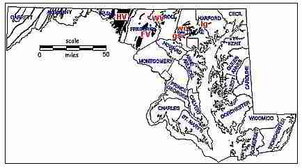
As pointed out by the Maryland Geological survey, Maryland karst terrains are limited to areas underlain by carbonate rocks.
In Maryland these areas most associated with collapse sinkholes are the Hagerstown Valley (HV), the Frederick Valley (FV), and the Wakefield Valley (WV).
To a lesser degree, collapse sinkholes are found in Green Spring Valley (gs), Worthington Valley (wo), and Long Green Valley (lg).
[Click to enlarge any image]
The Maryland karst location map (above) and excerpts from the referenced text are courtesy of Maryland Geological Survey. [MGS].
Quoting from the MGS:
In a type of karst known as cutter-and-pinnacle karst, the contact between bedrock and soil overburden is very irregular (see Fig. 2 and 3 for example).
Water preferentially dissolves bedrock along some planar feature, such as bedding, joints, or fractures, whichever is the easier path.
Roughly vertical, solutionally widened joints are called cutters, or grikes.
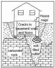 Cutters are generally filled with soil. The bedrock that remains between cutters may be reduced to relatively narrow "ridges" of rock, called pinnacles, particularly where cutters are closely spaced.
Cutter-and-pinnacle karst (or simply "pinnacle karst" for short) is common in many of the carbonate valleys in Maryland (Map above).
The problem develops when a building foundation lies on cutters and pinnacles. The weight of the building will compact the soil to some extent, and the building will settle. That is normal, and does not pose a problem as long as the building settles uniformly.
However, in pinnacle karst, part of the foundation may be supported by a bedrock pinnacle and part may be supported by a cutter (soil-filled).
The result can be differential settling of the building, which may produce cracks in the walls, foundation, and floor (sketch at left). This may compromise the structural soundness of the bearing walls and, therefore, place the safety of the whole structure in doubt.
The Maryland Geological Survey makes a helpful distinction between collapse or subsidence due to subsurface erosion (piping), and sudden collapse sinkholes (closed depressions).
Piping Sinkholes in Maryland
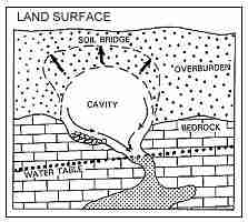
Piping is subsurface erosion of soil by percolating waters to produce pipe-like conduits underground. Piping can affect materials ranging from clay-size particles (less than 0.002 mm) to gravels (several centimeters), but is most common in fine-grained soils such as fine sand, silt, and coarse clay
. The resulting "pipes" are commonly a few millimeters to a few centimeters in size, but can grow to a meter or more in diameter. They may lie very close to the ground surface or extend several meters below ground.
Piping can become a problem in areas of cutter-and-pinnacle karst, as well as in some non-karst areas
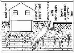
. As shown in in the MGS sketch below, what begins as piping can develop into cavities in the soil overburden. Piping tends to become accelerated when the water table is lowered by over-pumping ground water, when the amount of infiltrating water increases, or both.
(The "water table" marks the top of the zone of saturation, in which all pores and voids in bedrock and soil are filled with water.)
What can cause increased volume of water that infiltrates the soil overburden? Long periods of rainfall can be a factor, but man's activities also are significant.
Buildings with large roof areas, parking lots, streets and highways change the runoff and infiltration characteristics of soil by decreasing widespread, diffuse infiltration and channeling surface runoff to areas where more concentrated infiltration can occur.
The MGS illustration (above left)shows how runoff can be concentrated in the subsurface to create subsurface cavities. This is especially common in soil-filled cutters.
Collapse sinkholes in Maryland
 In Maryland, collapse sinkholes occur mainly in four areas: the limestones of the Hagerstown Valley in Washington County and the Frederick Valley in Frederick County, marble in the Wakefield Valley in Carroll County and, to a lesser degree, in marble valleys of Baltimore County (map above).
Collapse sinkholes seem to be most prevalent in the Frederick Valley and the Wakefield Valley. [Sketch left, courtesy of MGS].
As used in the Maryland MGS discussion, the term sinkhole refers exclusively to one type of closed depressions in karst landscapes. One type of sinkhole is the collapse sinkhole, so named because it forms suddenly when the land surface collapses into underground voids, or cavities.
Collapse sinkholes are often fairly circular with steeply sloping sides. They can be so small as to be barely noticeable to 50 meters or more in width and depth. Once formed, they can also grow larger.
[We illustrate and discuss collapse sinkholes also at Sinkholes in PENNSYLVANIA
In some karst terranes, collapse sinkholes form when the roof of a cave or cavern collapses. Such is the case in some collapses in Florida (Sinclair, 1982).
[See Sinkholes in FLORIDA]
However, most collapse sinkholes seem associated with cavities in the soil overlying the carbonate rock.
Some prefer the term cover collapse sinkhole to denote that collapse occurs in cavities in the soil overburden, or cover, rather than in the carbonate bedrock below. This is the general case for collapse sinkholes in areas of pinnacle karst in Maryland.
Other types of sinkholes form slowly by the dissolving of carbonate rock at or very near the surface.
They tend to have gently sloping sides, and they seldom pose a hazard by collapsing. Like collapse sinkholes, however, they can pose environmental problems related to pollution, because they provide a point where polluted surface runoff can directly flow into the ground water.
In the United States, according to one study, the states most impacted by collapse sinkholes are Alabama, Florida, Georgia, Missouri, Pennsylvania, and Tennessee (Newton, 1987).
"Sinkholes" that are not verified by a licensed professional geologist or geotechnical engineer to be a true sinkhole are also described in various publications as subsidence incidents.
Readers should see SINKHOLES - IMMEDIATE SAFETY ACTIONS, and also
see FOUNDATION CRACKS & DAMAGE GUIDE
The bare minimum that a property owner needs to know about sinkholes or any other sudden subsidence of soils at a property is that these conditions might be very dangerous.
Someone falling into a sink hole or into a collapsing septic tank could be seriously injured or even die.
If a suspicious hole, subsidence, or depression appears at a property the owner should rope off and prevent access to the area to prevent anyone from falling into the opening, and then should seek prompt assistance from a qualified expert, geotechnical engineer, septic contractor, excavator, or the like.
What to Do if you Suspect a Sinkhole in Maryland
The following is excerpted from (Sherwood 2004) cited in detail below on this page.
- STEP 1 Is the sinkhole located in or adjacent to a karst area? At least two resources
can be contacted to help make this determination:
1) The Maryland Geological Survey’s online Geologic Maps Series at www.mgs.md.gov/ helps determine the presence of karst-prone limestones, dolostones, or marble; or
2) Consult local soil maps to identify areas where soils originate from or overlie limestone and other material with some potential for developing sinkholes.
Soil survey maps and interpretive information are accessible through local Soil Conservation Districts or by visiting www.sawgal.umd.edu/nrcsweb/Maryland/index.htm. [The 2002 Frederick County Soil Survey contains a soil interpretation table outlining the relative potential for sinkhole formation by soil series.]
If the sinkhole is not within or near a karst area, subsidence may be due to conditions caused by past human practices (i.e. old foundations, abandoned wells, buried debris, etc.). - STEP 2
If a sinkhole is within a mile of a quarry operation, it may fall within the
Zone of Influence (ZOI), established by the Maryland Department of the
Environment.
[See page 13 in Sherwood's document given below on this page]
If it affects a Maryland state road, contact the State Highways Administration Engineers Office at 301-791-4790. - STEP 3
If the sinkhole is not within a ZOI, [Zone of Influence, also explained below on this page] the following local agencies should be
contacted:
Baltimore County Department of Environmental Protection and Resource Management will inspect and determine appropriate steps for all sinkholes. (Voice: 410-887-7428)
Carroll County Sinkholes Associated with Agricultural Uses: Carroll County Soil Conservation District will inspect and determine if a sinkhole is eligible for repair/mitigation cost share. (Voice: 410-848-8200)
Other sinkholes: Carroll County Bureau of Resource Management Program developed to map locations, provide technical assistance with repairs, and education on sinkhole occurrences. (Voice: 410-386-2639)
Frederick County Sinkhole affecting county roads and rights-of-way: Frederick County Office of Highway Operations. (Voice: 301-694-1564)
Sinkhole on Private Property: Frederick County Soil Conservation District. (Voice: 301-695-2803)
Washington County Sinkholes on County Roads or Highways: Washington County Highway Department. (Voice: 240-313-2720);
Washington County Engineering Department provides technical assistance/advice on sinkhole related problems on construction sites or existing dwellings: (Voice: 240-313-2400);
For general assistance or advice or to report sinkholes affecting streets in Hagerstown city limits, contact the City Engineers Office (Voice: 301-790-3200);
The County Soil Conservation District inspects and determines whether a sinkhole is eligible for MACs. (See page 15.) (Voice: 301-797-6821). ... Most local jurisdictions do not have programs or funding for sinkhole repair on residential or commercial/industrial property.
The level of technical assistance available depends on the jurisdiction, but might include an approximation of the sinkhole’s cause, potential for future occurrences or growth, proper repair techniques, and best-management practices to help avoid future occurrences.
More Information on Maryland sinkholes
- Benson, R. C., R. D. Kaufmann, L. B. Yuhr, and D. Martin. "Assessment, prediction and remediation of karst conditions on I-70, Frederick, Maryland." In Proceedings and Field Trip Guide of the 49th Highway Geology Symposium. 1998.
- Boyer, Bruce W. "Sinkholes, soils, fractures, and drainage: Interstate 70 near Frederick, Maryland." Environmental & Engineering Geoscience 3, no. 4 (1997): 469-485.
- Brezinski, David K., James P. Reger, and Gerald R. Baum. "Sinkhole susceptibility." In Meeting Challenges with Geologic Maps, American Geological Institute Environmental Awareness Series, pp. 36-37. 2004.
Excerpt:
Sinkholes, which abound in the Frederick Valley in west-central Maryland, impact urban growth and development....
Sinkholes form in carbonate areas as the dissolving and weakening of bedrock cause it to collapse. Activities, such as quarrying, which alter surface drainage and lower the water table also can decrease ground strength and exacerbate the sinkhole hazard.
It is important to assess potential risks of infrastructure damage and personal injury due to sinkhole formations. - Brezinski, David K., James P. Reger, and Gerald R. Baum. GEOLOGIC MAPPING AS A BASIS FOR SINKHOLE SUSCEPTIBILITY PREDICTION, FREDERICK VALLEY, MARYLAND [PDF] (2003).
Excerpt:
The Frederick Valley in west-central Maryland ... has an abundance of active, cover-collapse sinkholes—a situation complicated by population growth and concomitant development pressures ....
Altering surface drainage and lowering the ground-water table by quarry activities exacerbate the hazard.
Detailed geologic mapping (Brezinski, in progress) provides a basis for assessing potential infrastructure damage and personal injury, because the distribution of cover-collapse sinkholes is controlled primarily by the underlying geology. - Brezinski, David K., and James P. Reger. STRATIGRAPHY-KARST RELATIONSHIPS IN THE FREDERICK VALLEY OF MARYLAND [PDF] US Geological Survey Karst Interest Group Proceedings, Shepherdstown, West Virginia (2002): 59-65.
- Detecting Sinkholes with Geophysics, Enviroscan, Inc., Lancaster PA 717-396-8922 email@enviroscan.com www.enviroscan.com 2003
- Doctor, Katarina Z. "GIS and Spatial Statistical Methods for Determining Sinkhole Potential in Frederick Valley, Maryland." George Mason University,
Abstract:
Urban development is rapidly occurring in the karstic terrain of the Frederick Valley, Maryland, USA. Sinkholes are an inherent feature of the landscape; they present hazards and engineering challenges to the development of residential, commercial and industrial infrastructure. Here, a new approach is presented for assessing susceptibility of sinkhole occurrence. A sinkhole dataset and geologic map was obtained from the Maryland Geological Survey (Brezinski, 2004).
Clustering and kernel density analyses were performed on the sinkhole location data to assess interdependence of sinkhole locations.
External factors relating to sinkhole development were examined separately using Geographically Weighted Regression (GWR) and ordinary linear regression.
These factors included geologic structure (folds axes and faults), rock type, proximity to impervious surfaces and surface drainage patterns. In order to determine the relative likelihood of sinkhole formation, the results of the cluster analysis, density analysis, and regression analyses resulted in map layers that could be weighted and overlain to create a sinkhole susceptibility map.
Cluster analysis is important for analyzing sinkhole development for two reasons: 1) human activities tend to fill an empty space by creating a more uniform pattern than random, 2) the eye tends to “see clusters where none exist” as the result of the mind’s desire to organize spatial information (Rogerson, 2001).
Nearest neighbor analysis (NNA) is the most common method of cluster analysis; however, this method will not capture a pattern that is non-homogeneous over a study area (Wong, 2005).
The statistical method that is able to identify clustering in different scales is the K-function analysis, which compares the observed distribution of sinkholes to the same number of randomly distributed points. This method also considers the shape of the study region. In the Frederick Valley case study this was an important issue because of the elongated shape of the valley.
Sinkhole density is an important factor for determining the area most prone to sinkhole development.
Where a closed depression has collapsed into a sinkhole we know that the underlying subsurface contains unstable voids, and possibly a cave system. In areas where active sinkholes have developed there is a greater possibility that a new sinkhole will form (Brezinski, 2004; Zhou, 2003). Two methods were used to determine sinkhole density.
The first method is the Kernel Density Estimation (KDE) for which bandwidths were calculated with the previously described K-function analysis.
The second method takes into account a radial buffer area around each sinkhole and is expressed as the number of sinkholes inside each buffer zone. As a result each sinkhole receives an attribute that is the density of sinkholes within its surrounding radial buffer zone. This result is used later for further calculations for estimating sinkhole susceptibility.
Several geologic and anthropogenic factors were identified in Frederick Valley that influence sinkhole development. These factors include proximity of sinkholes to quarries, water-bodies, fault lines, anticline and syncline fold axes, streams, roads and ground-water table depth (Zhou, 2003; Brezinki, 2004; Magdalene, 1995; Ordorff, 2000; Hack, 1965). The locations of these features are known from detailed geologic maps (Brezinski, 2004).
Geographically Weighted Regression (GWR) analysis was used to express the significance of these factors in relation to sinkhole density. GWR is a multivariate regression which assumes that the relationship of weights of each influencing factor vary across space. From the GWR results, a map surface was produced for predicting highest sinkhole density using the Inverse Distance Weights method (Fig. 1). These results may be a guide for future development activities in this region and others like it. - Doctor, Katarina Z., Daniel H. Doctor, Barry Kronenfeld, David WS Wong, and David K. Brezinski. "Predicting Sinkhole Susceptibility in Frederick Valley, Maryland Using Geographically Weighted Regression." In Sinkholes and the Engineering and Environmental Impacts of Karst, pp. 243-256. 2008.
Abstract:
A dataset of 556 collapsed sinkholes covering six 1:24,000 scale geologic quadrangles was analyzed in order to map the relative likelihood of sinkhole formation in Frederick Valley, Maryland, USA.
Factors that help predict the density of sinkholes included clustering of sinkholes, geologic structure, rock type, and proximity to: quarries, water bodies, streams, roads, faults, axes of synclines or anticlines, and depth to groundwater.
Spatial statistical analyses (K-function, Geographically Weighted Regression (GWR) and Inverse Distance Interpolation) were performed to calculate sinkhole density potential within the study area. K-function analysis was performed to find the clusters over different spatial scales.
Using these results sinkhole density was determined for each sinkhole location. Relations of external factors to the calculated interdependent sinkhole density were then examined using Geographically Weighted Regression.
The result is a map of sinkhole susceptibility that considers geologic, hydrologic, and anthropogenic factors. The results show that the proximity to the groundwater table, proximity to fold axes, proximity to faults, and proximity to quarries are the factors that significantly influence new sinkhole development, in order of decreasing significance.
These results may be a guide for future development activities in this region and others like it. - Foundation Engineering Problems and Hazards in Karst Terranes, James P. Reger, Maryland Geological Survey, web search 06/05/2010, original source: http://www.mgs.md.gov/esic/fs/fs11.html
- Maryland Geological Survey, SINKHOLES & MARYLAND GEOLOGY, MGS, Maryland Geological Survey, Maryland Geological Survey
Richard A. Ortt, Jr., Director
2300 St. Paul Street, Baltimore, MD 21218
(410) 554-5500
USA, retrieved 2021/10/24 original source: http://www.mgs.md.gov/geology/geohazards/sinkhole_index.html
Excerpt:
A sinkhole is a circular depression, typically funnel-shaped, that can form in a karst area. Karst is a type of topography formed on carbonate rock such as limestone or dolomite, and characterized by sinkholes, caves and open-channel groundwater flow. In Maryland, karst areas occur in Baltimore, Carroll, Washington, and Frederick Counties, with less extensive areas in Allegany County.
Depressions that form on karst areas may be sinkholes, however, every depression or hole in the ground isn’t necessarily a sinkhole. Depressions in the land may also be a result of rotted tree stumps, collapsed underground structures such as old spetic tanks, stormwater runoff, and leaking underground pipes.
True sinkholes do not form in areas underlain by hard, crystalline rock present in central and western Maryland nor in the unconsolidated sediments of Maryland's Coastal Plain (area approximately east of I-95). - Maryland Geological Survey, SINKHOLES in WESTERN MARYLAND [PDF] Maryland Geological Survey
Richard A. Ortt, Jr., Director
2300 St. Paul Street, Baltimore, MD 21218 USA
(410) 554-5500
, retrieved 2021/10/24 original source: http://www.mgs.md.gov/geology/geohazards/sinkholes_in_maryland.html
Excerpts:
MGS staff members estimate that Frederick County alone contains a vulnerable karst topography covering about 35 square miles.
Washington County is estimated to have a karst area of two or three times that size.
The Geological Survey has identified more than 1,000 “karst features,” including 125 sinkholes, in a relatively small portion of Frederick County.
From this, we know that hundreds of sinkholes are likely to exist in each of the three most-affected counties, Washington, Frederick, and Carroll. - Porteous, James N. "Creation Of A Sinkhole Density Map Of Carroll County, Maryland." (2014).
- Reger, James P., Foundation Engineering Problems and Hazards in Karst Terranes, James P. Reger, Maryland Geological Survey, web search 06/05/2010, original source: http://www.mgs.md.gov/esic/fs/fs11.htmlMaryland Geological Survey, 2300 St. Paul Street, Baltimore, MD 21218 http://www.mgs.md.gov/index.html
- Sherwood, Topper, A USER'S GUIDE TO KARST and SINKHOLES in WESTERN MARYLAND [PDF] (2004) Western Maryland Resource Conservation & Development Council, WESTERN MARYLAND RC&D
18450 Showalter Road, Suite 111
Hagerstown, MD 21742-1383
Voice: (301) 733-2973
Fax: (301) 733-7643
E-mail: wmarylandrcd@starpower.net
URL: users.erols.com/wmarylandrcd/
Excerpts:
This guide was written to help people who live and work in Maryland to be more aware of the issues presented by karst topography, a geological terrain whose most well-known characteristics are solution cavities, caves, and sinkholes.
The developers of this guide represent local agencies that assist residents and business owners with questions about land, water, and karst. We work to help others understand the nature of land and water in our region, and to become more aware of the need for good conservation practices.
...
Maryland Sinkholes and ZOIs - Zones of Influence
Under a 1991 Amendment to Maryland’s Surface Mining Law, the Maryland Department of the Environment (MDE) is required to establish and define Zones of Influence (ZOIs) around limestone and marble quarries in Baltimore, Carroll, Frederick, and Washington counties. Limestone mining operations are required to repair a sinkhole within a ZOI if MDE determines that the sinkhole resulted from quarry dewatering.
Extraction companies also are required to replace a water supply that fails due to declining water levels caused by a quarry’s water-pumping operation. If the sinkhole damage cannot be restored to its pre-subsidence condition, the quarry owner must pay monetary compensation to the affected property owner(s). MDE investigates complaints of sinkhole or water-supply failure within a Zone of Influence.
A quarry’s ZOI is based upon local topography, watersheds, geologic and hydrologic factors. When establishing Zones of Influence, MDE conducts field investigations and evaluates any available information such as groundwater studies and well-monitoring data.
Anyone wishing to report complaint of a sinkhole or water-supply failure should contact MDE’s Mining Program at (410) 537-3557. Those purchasing homes within limestone (karst) terrains should inquire about limestone mining. MDE should be contacted to acquire ZOI maps. - Zhou, Wanfang, Barry F. Beck, and Angela L. Adams. "Application of matrix analysis in delineating sinkhole risk areas along highway (I-70 near Frederick, Maryland)." Environmental Geology 44, no. 7 (2003): 834-842.
Abstract:
Sinkhole collapse in the area of Maryland Interstate 70 (I-70) and nearby roadways south of Frederick, Maryland, has been posing a threat to the safety of the highway operation as well as other structures. The occurrence of sinkholes is associated with intensive land development.
However, the geological conditions that have been developing over the past 200 million years in the Frederick Valley control the locations of the sinkholes. Within an area of approximately 8 km2, 138 sinkholes are recorded and their spatial distribution is irregular, but clustered. The clustering indicates the existence of an interaction between the sinkholes.
The point pattern of sinkholes is considered to be a sample of a Gibbsian point process from which the hard-core Strauss Model is developed. The radius of influence is calculated for the recorded sinkholes which are most likely to occur within 30 m of an existing sinkhole. The stochastic analysis of the existing sinkholes is biased toward the areas with intensive land use.
This bias is adjusted by considering (1) topography, (2) proximity to topographic depressions, (3) interpreted rock formation, (4) soil type, (5) geophysical anomalies, (6) proximity to geologic structures, and (7) thickness of overburden.
Based on the properties of each factor, a scoring system is developed and the average relative risk score for individual 30-m segments of the study area is calculated. The areas designated by higher risk levels would have greater risk of a sinkhole collapse than the areas designated by lower risk levels. This risk assessment approach can be updated as more information becomes available.
Daniel Friedman - Florida Suncoast ASHI Educational Seminar - 1 May 2004, updated 2007, 2008, 2014, 2017, 2021.
Portions of this text are extracted, quoted, or paraphrased from references provided; a key resource author was Sarah Cervone at Reference-1. The document is at InspectAPedia.com/vision/Sinkholes_Subsidences.php - © 2021 - 2009 Daniel Friedman All Rights Reserved
...
Continue reading at SINKHOLE DAMAGE REPAIRS or select a topic from the closely-related articles below, or see the complete ARTICLE INDEX.
Or see these
Sinkhole & Subsidence Articles
Suggested citation for this web page
SINKHOLES in MARYLAND at InspectApedia.com - online encyclopedia of building & environmental inspection, testing, diagnosis, repair, & problem prevention advice.
Or see this
INDEX to RELATED ARTICLES: ARTICLE INDEX to SINKHOLES
Or use the SEARCH BOX found below to Ask a Question or Search InspectApedia
Ask a Question or Search InspectApedia
Questions & answers or comments about sinkholes and their effects on buildings.
Try the search box just below, or if you prefer, post a question or comment in the Comments box below and we will respond promptly.
Search the InspectApedia website
Note: appearance of your Comment below may be delayed: if your comment contains an image, photograph, web link, or text that looks to the software as if it might be a web link, your posting will appear after it has been approved by a moderator. Apologies for the delay.
Only one image can be added per comment but you can post as many comments, and therefore images, as you like.
You will not receive a notification when a response to your question has been posted.
Please bookmark this page to make it easy for you to check back for our response.
IF above you see "Comment Form is loading comments..." then COMMENT BOX - countable.ca / bawkbox.com IS NOT WORKING.
In any case you are welcome to send an email directly to us at InspectApedia.com at editor@inspectApedia.com
We'll reply to you directly. Please help us help you by noting, in your email, the URL of the InspectApedia page where you wanted to comment.
Citations & References
In addition to any citations in the article above, a full list is available on request.
- Waltham, Tony, Frederic Gladstone Bell, and M. G. Culshaw, Sinkholes and subsidence, [at Amazon.com] Springer/Praxis, 2005.
- [1] Thomas V. Cech, Principles of water resources: history, development, management, and policy, John Wiley and Sons 2009 ISBN0470136316, 9780470136317
- Newton, J. G., 1987, Development of sinkholes resulting from man's activities in the eastern United States: US Geological Survey Circular 968, 54 p.
- Avongard FOUNDATION CRACK PROGRESS CHART [PDF] - structural crack monitoring
- Building Failures, Diagnosis & Avoidance, 2d Ed., W.H. Ransom, E.& F. Spon, New York, 1987 ISBN 0-419-14270-3
- "A Foundation for Unstable Soils," Harris Hyman, P.E., Journal of Light Construction, May 1995
- "Inspecting Block Foundations," Donald V. Cohen, P.E., ASHI Reporter, December 1998. This article in turn cites the Fine Homebuilding article noted below.
- "When Block Foundations go Bad," Fine Homebuilding, June/July 1998
- In addition to citations & references found in this article, see the research citations given at the end of the related articles found at our suggested
CONTINUE READING or RECOMMENDED ARTICLES.
- Carson, Dunlop & Associates Ltd., 120 Carlton Street Suite 407, Toronto ON M5A 4K2. Tel: (416) 964-9415 1-800-268-7070 Email: info@carsondunlop.com. Alan Carson is a past president of ASHI, the American Society of Home Inspectors.
Thanks to Alan Carson and Bob Dunlop, for permission for InspectAPedia to use text excerpts from The HOME REFERENCE BOOK - the Encyclopedia of Homes and to use illustrations from The ILLUSTRATED HOME .
Carson Dunlop Associates provides extensive home inspection education and report writing material. In gratitude we provide links to tsome Carson Dunlop Associates products and services.


