
InspectAPedia® FREE Encyclopedia of Building & Environmental Construction, Diagnosis, Maintenance & Repair |
Question? Just ask us! InspectAPedia
|
 Flood Zones in the U.S.
Definition of flood zones, flood zone maps, insurance, advice for buildings located in areas prone to flooding
- POST a QUESTION or COMMENT about flood zones: how flood zones are determined, what is a flood zone, how to find out if your building is located within a flood zone, how flood zones affect flood insurance rates, where & how to get a detailed flood zone map and flood insurance rate map or FIRM
Flood zones & flood zone maps: what is a flood zone, how are flood zones defined, and where can we see maps that define flood zone areas? How does location in or out of a flood zone affect the cost of flood insurance? These questions and their answers are discussed in this article.
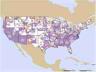
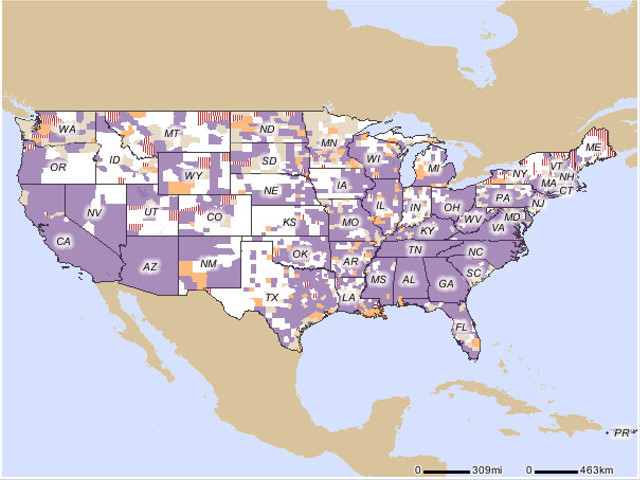
The map shown at page top is provided by FEMA's flood map viewer and indicates (in purple) 2,655 areas within the continental U.S. for which Digital Flood Insurance Rate Map (DFIRM) data is available.
InspectAPedia tolerates no conflicts of interest. We have no relationship with advertisers, products, or services discussed at this website.
- Daniel Friedman, Editor/Publisher - See WHO ARE WE?
What is a Flood Zone & What does Being in a Flood Zone Mean to a Building Owner or Tenant?
[Click to enlarge any image]
A flood zone is a geographic or land area that FEMA (or in other countries other agencies) has defined as being subject to flooding and thus flood damage.
Flood Damage Insurance for Homes in Flood Zones
Buildings constructed, re-built, or repaired within a designated flood zone require additional steps to protect the building from future flood damage (or flood and storm damage) or to reduce the extent of that damage.
Depending on the type of flood zone, building owners and tenants may have flood insurance available or may be required to purchase it.
Article Contents
- FLOOD ZONES & FLOOD ZONE MAPS
- What are the Categories of Flood Zone Designation?
- How are flood zones defined or determined?
- How to Determine Whether or Not Your Home is Within a Designated Flood Zone or Flood-Prone Area
- New FEMA Flood Zone Designation Maps
- How to Find & Print a Free (or Purchased) Copy of Your Flood Zone Map
- Flood Insurance Rate Maps (FIRMS) and Creating a FIRMette document
- How to Contact FEMA Map Service Center for Help with Flood Zone Maps
But even if your home is not located in a primary flood zone you might be smart to purchase flood insurance. (Flood maps are explained later in this article). USAA, a national financial and insurance company serving the military gives this advice:
Flood insurance is mandatory when you have a mortgage on a home in a high-risk flood area. Even if you live outside a high-risk area, don't make the mistake of assuming you'll never experience a flood. In fact, more than 25% of flood losses occur in areas considered at moderate or low risk.
Whether it's a flash flood or just a few inches from a rainstorm, water can cause massive damage to your home and belongings — and if you're not financially prepared, the effects can be devastating. The National Flood Insurance Program has teamed with USAA and other insurers to offer flood insurance. Premiums, which vary depending on where you live, start at just $129 a year.[31]
National Flood Insurance Program NFIP
Flood insurance is not normally provided by nor included in a standard homeowners insurance policy. Rather flood damage insurance in the U.S. is sold under the National Flood Insurance Program - NFIP. NFIP is not an agency itself but rather is an insurance program administered by consortium of private insurance companies that offer flood damage insurance under the NFIP which is in turn "run" by FEMA, the Federal Emergency Management Agency.
What this means to the homeowner is that while s/he may have purchased flood damage indurance under NFIP, a program bearing the term "national" in its name and run by a national agency, FEMA, when flood damage occurs it is a private insurance company and a private adjuster hired by that insurer who will visit the home, make a damage assessment, and offer an insurance payment.
Homeowners who are not satisified with the offering may need to hire a public adjuster, another independent agent, to negotiate in their behalf with the insurance company. As The New York Times pointed out in March 2013 in discussing dissatisfaction with flood damage coverage following 2012's Hurricane Sandy, FEMA's handling of flood insurance has been criticized for being "... very shy about taking on the insurance companies". [30]
The role of Flood Zone Maps in Flood Damage Insurance and the NFIP
Flood Zone Maps or Flood Insurance Rate Maps (FIRMS) and FIRMette documents are used to determine if flood insurance is available, optional, or required for a given property, home, or business.
Watch out: Do not enter a flooded, storm damaged,or earthquake or hurricane-damaged building if the building is still flooded or has not been determined by an expert to be safe to enter.
Basic guidelines for entering a flooded building are
at Do Not Enter a Building in The Following Conditions.
See BUILDING ENTRY for FLOOD DAMAGE
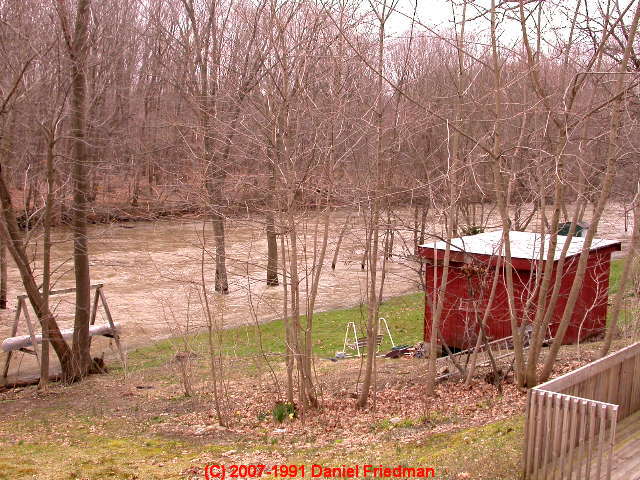
Shown at above left is flooding along Wappingers Creek in Dutchess County, New York. Below we demonstrate the process of finding FEMA flood zone designation maps for the area shown in this photograph.
How are flood zones defined or determined?
In the U.S. flood zones and flood zone maps are defined by FEMA, the Federal Emergency Management Agency, a U.S. government Agency operating under Public Law 100-707. For purposes of emergency management FEMA divides the U.S. into ten regions for each of which FEMA maintains a coordinating office. Details and contact information for FEMA and each FEMA region are
at FEMA Regional Office Contact Information & Telephone Numbers.
This article series gives action & repair priorities if your building has been flooded, or damaged by another disaster in an easy to understand guide. We describe procedures for for flood damage assessment, setting priorities of action, safe entry procedures for damaged buildings, first steps to protect a building from further damage, how to dry out the building, how to return the utilities to operation, how to clean up a flooded or damaged basement or building, how to rebuild a damaged building, and how to prepare to minimize danger and damage hazards from future disasters. We also provide special information about avoiding or minimizing mold damage in wet or flooded basements or buildings.
What are the Categories of Flood Zone Designation?
Flood zones are defined by FEMA in both general categories and within each of those categories in additional levels of details. The four general flood zone risk categories are:
- Moderate to Low Risk Areas of Flooding.
These areas are inside the 100-year and 500-year flood risk zone and include areas protected from flooding by levees and areas vulnerable to shallow flooding to average depths of one foot or to flood-prone drainage areas that are less than a square mile in area.
In these areas, within communities that participate in the U.S. National Flood Insurance Program (NFIP), flood insurance is available to both property owners and renters, but its purchase is optional. - High Risk Areas for Flooding & Flood Damage,
defined as "Areas with a 1% annual chance of flooding and a 26% chance of flooding over the life of a 30-year mortgage." In these areas and in communities that participate in the NFIP, flood insurance is required. Seven additional subcategories of High Risk Areas for Flooding are provided. [10] - High Risk Areas for Flooding in Coastal Zones,
defined as "Coastal areas with a 1% or greater chance of flooding and an additional hazard associated with storm waves. These areas have a 26% chance of flooding over the life of a 30-year mortgage." In these areas, in communities participating in the NFIP, flood insurance is required. - Undetermined Flood Risk Areas.
These are geographic areas for which there may be risks of flooding but no flood hazard analysis has been made. Flood damage insurance rates are set "commensurate with the uncertainty of the flood risk"[10]
How to Determine Whether or Not Your Home is Within a Designated Flood Zone or Flood-Prone Area
Although not all areas of the U.S. have yet been mapped as inside or outside of designated flood zone areas, in general, and especially in coastal and high-risk areas, many homeowners or tenants can already determine whether or not their property is in fact located within a designated flood zone, and Homeowners can dispute the designation of their property as inside or outside of a flood zone. Owners whose building is listed as located in a FEMA-designated flood zone should receive a letter indicating that status.
To determine whether or not your property is within a flood zone, consult the FEMA website or FEMA-provided flood zone maps that we describe and illustrate just below.
FEMA provides an online tool that produces a Letter of Map Change that can provide a document certifying the updated status of your building in (or out of) a flood zone.
New FEMA Flood Zone Designation Maps Add Homes to Designated Flood Prone Areas
In 2013 the U.S. Federal Emergency Management Association (FEMA) released new flood zone maps for the United States indicating that areas to be designated as at high risk for flooding and flood damage have been substantially extended.
The new flood zone maps consider recent weather changes associated with global warming, recent storms and storm damage such as Hurricane Sandy that flooded and damaged parts of the Northeastern U.S. in 2012, but not anticipated increases in the frequency and severity of storms and related floods.
As we expect global warming and its effects on the frequency and extremity of weather events to increase, one might interpret the new flood zone maps as conservative in estimating the level of flood damage risk faced by building owners and occupants in the coming decade or longer.
For the New York City area alone, in January 2013 the New York Times reported that the number of homes within designated high risk flood areas was doubling, adding an additional 35,000 homes and businesses into the updated FEMA flood zone map data.[11]
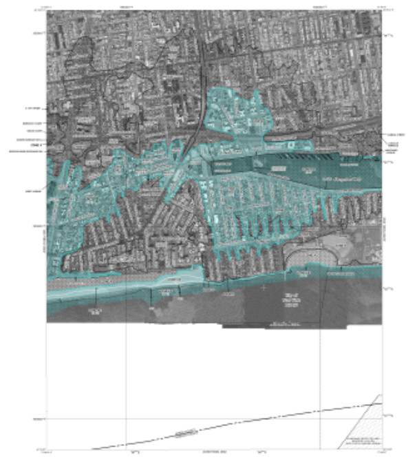
At above-left is the FEMA Flood Zone Map obtained by searching for Oriental Boulevard, in FEMA's New York City Flood Zone Map. We found the free online maps helpful but distressingly blurry with illegible details. The printed maps that can be ordered from FEMA are completely legible, detailed, can be zoomed-in to read details, and cost $4.00 for a print form or $2.50 for an on-line map.[10]
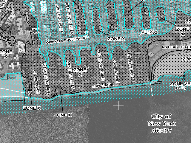
We purchased the online version of the FEMA map above. The procedure produces a nicely detailed 16MB map as a xxx.png file - the map image.
At left we include an excerpt from that map demonstrating the level of detail that can be displayed, in this case for Oriental Boulevard in Brooklyn, NY.
For purposes of determining flood insurance rates under the National Flood Insurance Program (NFIP), and because homes and businesses located within high risk flood-zone designations can be required to obtain and pay for flood insurance, the new maps won't take effect until 2015.
However people re-building structures damaged by Hurricane Sandy in 2012 will want to consider additional flood proofing measures both because of increased flooding risks and because of the impact of NFIP insurance requirements and NFIP insurance premiums.
How does location in or out of a flood zone impact the amount of flood insurance premiums?
The same Times article gave a flood insurance premium example explaining that owners of a home located in a designated flood zone and built with a "half basement" whose floor is four-feet below ground level might have to pay twenty-two times as much for flood insurance as a structure built three feet higher than the anticipated flood line or level.[11]
How to Find & Print a Free (or Purchased) Copy of Your Flood Zone Map
In the U.S. flood zone maps are provided by FEMA and are easily accessed through the FEMA Map Service Center - search the FEMA website at https://msc.fema.gov for "Flood Maps" or ask for help from
It is possible to search flood zone maps by the actual property address, by searching FEMA's product catalog, or by ordering a map from FEMA. To find the flood zone map for any area simply area in the United States just enter the address in the search window for this page.
FEMA's flood zone maps can be viewed online (zoom-in for a usable map) and can also be purchased from FEMA in print form. As FEMA's website advises, you'll have to be patient to wait for your flood area map to load.
Finding the exact flood zone map details surrounding your exact property using FEMA's online maps can be a little difficult unless you have first found your own address or property on a more legible Google Map or other map.
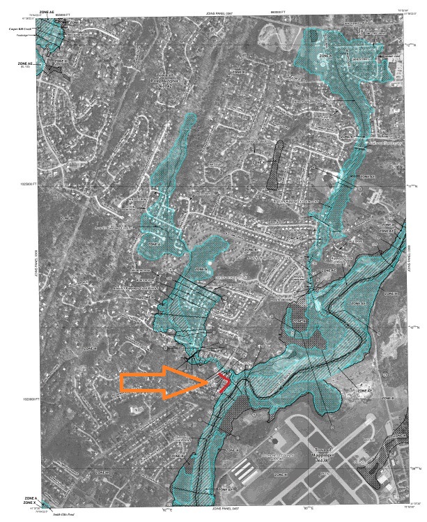
As a test we searched for an arbitrary address known to be near a creek and low area subject to flooding in Dutchess County, New York. Searching for 1 Willowbrook Heights, Poughkeepsie, NY 12603, produced the map shown at below left [click to enlarge].
Zooming in on the flood map using the FEMA web page ZoomWin tool (not the Zoom In tool which was not helpful) produced he second image (below right) on which the local Dutchess County airport served as a landmark. We zoomed on the map area that we knew contained the street of interest - Willowbrook Heights - marked in red and pointed-to by a large orange arrow on each map. The colored markings are our additions and are not provided by the FEMA flood zone map tool.
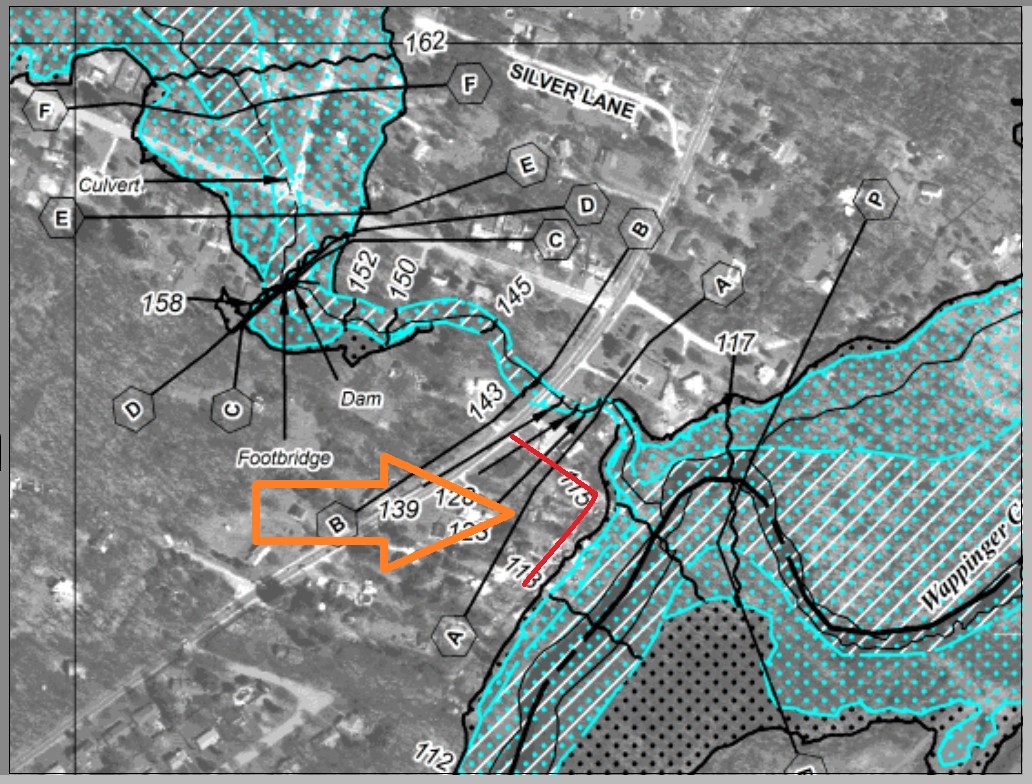
The detailed FEMA flood zone map at above if you enlarge it, shows helpful details such as local dams, footbridges, and the elevations in feet above the flood plain.
[Click to enlarge any image]
For now you might find as we did that the most useful flood zone map you can produce from FEMA's data is made by zooming in on the map and then using a screen save utility to keep the image that you produce.
Flood Insurance Rate Maps (FIRMS) and Creating a FIRMette document
FEMA provides a FIRMette tool that can be used to make a detailed map showing the area of interest, on a Flood Insurance Rate Map (FIRM). Before buying a map, try using the FIRMette tool - there is no cost.
Watch out: we found that FEMA's FIRMette tool and page were not quite working (January 2013) and could not be induced to actually produce a usable detailed map of our area of interest.
The image below is as far as we could get before the FIRMette hung. An easy workaround for this problem is available by selecting the map purchase option from the FEMA maps options. If you accept electronic delivery of a map document the cost is just $2.50.

How to Contact FEMA Map Service Center for Help with Flood Zone Maps
- Contact the FEMA Map Information eXchange (FMIX) at 1-877-FEMA MAP (336-2627).
- The FEMA website is found at https://msc.fema.gov
- See FEMA Regional Office Contact Information & Telephone Numbers (here at InspectApedia)
...
Continue reading at ELECTRICAL SAFETY for Flood Damage Inspectors or select a topic from closely-related articles below, or see our complete INDEX to RELATED ARTICLES.
Or see these
Recommended Articles
- FLOOD & DISASTER BUILDING DAMAGE REPAIR PROCEDURES - home
- Step 1. TAKE CARE OF YOURSELF FIRST
- Step 2. GIVE YOUR HOME FIRST AID
- Step 3. GET ORGANIZED
- Step 4. BUILDING DRY-OUT PROCEDURES
- SALVAGE BUILDING CONTENTS
- Step 5. RESTORE UTILITIES AFTER FLOODING
- MOLD CONTROL, FLOOD RESPONSE
- Step 6. FLOOD DAMAGED BUILDING CLEAN-UP
- Step 7. CHECK ON FINANCIAL ASSISTANCE
- Step 8. REBUILD & FLOODPROOF
- Step 9. FLOOD & STORM INSURANCE
- FLOOD-CAUSED MOLD PREVENTION
- FLOOD REPAIR CONTRACTORS
- WHEN TO STOP LOOKING FOR MOLD
- FLOOD & STORM DAMAGE REFERENCES for damage assessment & cleanup
- HURRICANE DAMAGED BUILDINGS
- HURRICANE, WIND, & STORM-RESISTANT WINDOWS
- WIND DAMAGED BUILDINGS
Suggested citation for this web page
FLOOD ZONES & FLOOD ZONE MAPS at InspectApedia.com - online encyclopedia of building & environmental inspection, testing, diagnosis, repair, & problem prevention advice.
Or see this
INDEX to RELATED ARTICLES: ARTICLE INDEX to BUILDING DAMAGE, DISASTER, REPAIRS
Or use the SEARCH BOX found below to Ask a Question or Search InspectApedia
Or see
INDEX to RELATED ARTICLES: ARTICLE INDEX to BUILDING STRUCTURES
Or use the SEARCH BOX found below to Ask a Question or Search InspectApedia
Ask a Question or Search InspectApedia
Try the search box just below, or if you prefer, post a question or comment in the Comments box below and we will respond promptly.
Search the InspectApedia website
Note: appearance of your Comment below may be delayed: if your comment contains an image, photograph, web link, or text that looks to the software as if it might be a web link, your posting will appear after it has been approved by a moderator. Apologies for the delay.
Only one image can be added per comment but you can post as many comments, and therefore images, as you like.
You will not receive a notification when a response to your question has been posted.
Please bookmark this page to make it easy for you to check back for our response.
Our Comment Box is provided by Countable Web Productions countable.ca
Citations & References
In addition to any citations in the article above, a full list is available on request.
- [1] REPAIRING YOUR FLOODED HOME [PDF], American Red Cross & FEMA: Federal Emergency Management Agency, FEMA PO Box 2012, Jessup MD 20794-2012. Printed copies of this book are available from the American Red Cross, from your local Red Cross chapter, or by writing to the address above. Web search 10/4/2010, original source: http://www.redcross.org/www-files/Documents
/pdf/Preparedness/file_cont333_lang0_150.pdf - [2] The following are available free from:
Federal Emergency
Management Agency
Attn: Publications
P. O. Box 2012
Jessup, MD 20794-2012
- Design Manual for Retrofitting Flood-prone Residential Structures, FEMA-114. This detailed manual explains all the flood proofing options in language a homeowner can understand.
- Elevated Residential Structures, FEMA-54.
- Flood proofing Non-residential Structures, FEMA-102.
- Coastal Construction Manual, FEMA-55.
- Manufactured Home Installation in Flood Hazard Areas, FEMA 85.
- [3] The following are available for free from: U.S. Army Corps of Engineers Attn: CECW-PF
20 Massachusetts Avenue, NW Washington, D.C. 20314
- Introduction to Flood Proofing, John R. Sheaffer, 1967
- Flood-Proofing Regulations, U.S. Army Corps of Engineers, Pittsburgh District, 1990, 80 pages (Corps publication EP 1165 3 314).
- Flood Proofing Systems & Techniques, L.N. Flanagan, editor, 1984
- Flood Proofing Tests, Tests of Materials and Systems for Flood Proofing Structures, Corps of Engineers, National Flood Proofing Committee, August, 1988.
- Raising and Moving the Slab- On-Grade House, Corps of Engineers National Flood Proofing Committee, 1990.
- [4] The following publications are
available from the American Red
Cross. Contact your Red Cross
chapter for more information:
- Your Family Disaster Plan (ARC 4466)
- Su plan para el hogar en caso de desastres (ARC 4466S)
- Your Family Disaster Supplies Kit (ARC 4463)
- Su Equipo de suministros para la familia en caso de desastres (ARC 4463S)
- Safe Living in Your Manufactured Home (ARC 4465)
- Are You Ready for a Flood or Flash Flood? (ARC 4458)
- ¿Está preparado para una inundación or inundación súbita? (ARC 4458S)
- Are You Ready for a Hurricane? (ARC 4454)
- ¿Está preparado para un huracán? (ARC 4454S)
- [5] Clean up References Many Cooperative Extension Service offices have home economists and food and farm experts. Check your telephone book under the county name. For example, if you live in Pittsburg County, check under “Pittsburg County Cooperative Extension Service”.
- [6] Questions on cleaning or disinfecting of specific materials can be answered by manufacturers of cleaning products. Check the product labels for toll free telephone numbers.
- [7] References on technical aspects of flood proofing can be located through the Floodplain Management Resource Center, a free service provided by the Association of State Floodplain Managers. Call 303/492-6818
- [8] CMHC, Canadian Mortgage and Housing Corporation, "After the Flood — A Homeowner’s Checklist", retrieved 10/21/2012, original source http://www.cmhc-schl.gc.ca/en/co/maho/em/em_001.cfm [copy on file as After_The_Flood_CMHC.pdf]
- [9] Robert T. Stafford Disaster Relief & Emergency Assistance Act, June 2007, full document [large PDF] Retrieved 12 /3/2012, original sourc: https://www.fema.gov/library/viewRecord.do?id=3564, [copy on file as Stafford_Act_FEMA_2007.pdf]
- [10] FEMA, "Definitions of FEMA Flood Zone Designations ", web search 1/30/2013, original source: https://msc.fema.gov/webapp/wcs/ stores/servlet/info?storeId=10001 &catalogId=10001&langId=-1&content=floodZones&title= FEMA%20Flood%20Zone%20Designations, copy on file as FEMA Flood Zone Designations.pdf
- [11] Cara Buckley, "Twice as Many Structures in FEMA's Redrawn Flood Zone", The New York Times, 29 January 2013, p. A16 & A19.
- [25] Como Reparar su Hogar Inundado American Red Cross and FEMA - PDF - espanol
- [26] Flood Cleanup - Avoiding Indoor Air Quality Problems US EPA Fact Sheet
- [29] "A Brief Guide to Mold, Moisture, and Your Home", U.S. Environmental Protection Agency US EPA - includes basic advice for building owners, occupants, and mold cleanup operations. See http://www.epa.gov/mold/moldguide.htm
- [30] Tara Siegel Bernard, "FIghting the Insurer Over Hurricane Sandy Damage", The New York Times, 2 March 2013, p. B1, B5.
- [31] USAA, " What Homeowners Insurance Doesn't Cover - Having a policy in place doesn't necessarily mean your home and belongings are protected against all losses", USAA 9800 Fredericksburg Road San Antonio, TX 78288, https://www.usaa.com/inet/pages/ advice-disaster-whatsnotcovered? offerName=prihome_advice-disaster-whatsnotcovered, retrieved 3/5/2013
- In addition to citations & references found in this article, see the research citations given at the end of the related articles found at our suggested
CONTINUE READING or RECOMMENDED ARTICLES.
- Carson, Dunlop & Associates Ltd., 120 Carlton Street Suite 407, Toronto ON M5A 4K2. Tel: (416) 964-9415 1-800-268-7070 Email: info@carsondunlop.com. Alan Carson is a past president of ASHI, the American Society of Home Inspectors.
Thanks to Alan Carson and Bob Dunlop, for permission for InspectAPedia to use text excerpts from The HOME REFERENCE BOOK - the Encyclopedia of Homes and to use illustrations from The ILLUSTRATED HOME .
Carson Dunlop Associates provides extensive home inspection education and report writing material. In gratitude we provide links to tsome Carson Dunlop Associates products and services.
 | HOME | ABOUT | ASK a QUESTION | CONTACT | CONTENT USE POLICY | DESCRIPTION | POLICIES | PRIVACY | |
| © 2024 - 1985 Publisher InspectApedia.com - Daniel Friedman | |||||||||